Don't like the adverts?  Click here to remove them

Alps Maritimes - 2015

SpinDrift

Well-Known Member
Supporter
Joined
Mar 18, 2010
Messages
1,189
Garage
In September we crossed over to France and headed south to tour the Alpes Maritimes.

Our route followed significant parts of the Louvot road books: VALLEE DE LA ROYA / VAL DES MERVEILLES / PISTE DES FORTS / MARGUAREÏS http://guide4x4.free.fr/topic2/page3.html and NICE – VAL D'ISERE par la France http://guide4x4.free.fr/topic2/page9.html - this last book being the main one. We had used Louvot's Romania road book on last year's trip. We have found these roadbooks to be excellent. Others on here have also used these books.

Door to door we covered some 4,440kms over 11 days, consuming 631 litres of diesel. The average price of diesel in France was 92p per litre with the most expensive being on the motorway just ourside Calais (on the way back) at £1.05 and the cheapest being from a supermarket petrol station at 85p! Tolls/road tax added up to £249 with the most expensive being the Tunnel de Frejus crossing from Italy to France at £34 and the Swiss vignette, another £34, as we took a shortcut through Switzerland as we headed for Alsace.

Most nights we wild camped in forests and fields, but we also used a few camp sites.

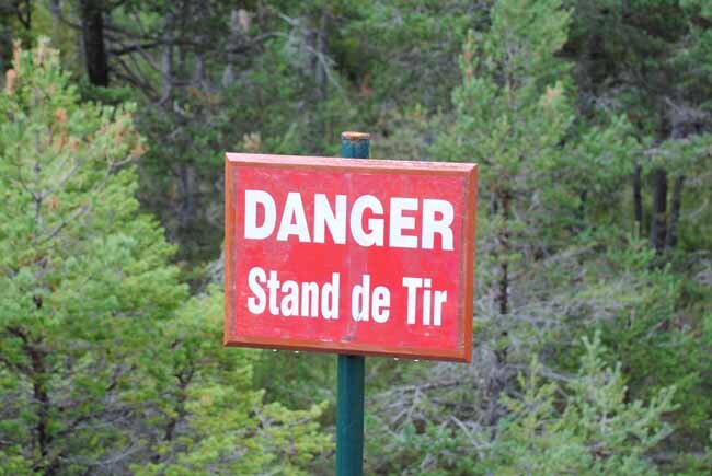
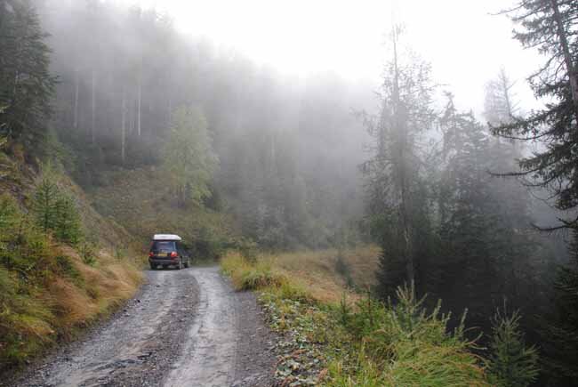
We covered around 400 kms of track - a mix of gravel, dirt and rock, through mountainous country, in forest and above the treeline. Most of the tracks were relatively easy going - with the biggest challenges being the narrowness of the tracks, especially where tracks had been reopened after avalanches, with sheer drops on the side.

The only recovery gear we used was the car jack - to change a wheel when we found a nail in the tyre. The only other damage we suffered were two ripped inner boots on either sides of the front diff.

map.jpg

We thoroughly enjoyed the trip. The landscape and views were pretty spectacular. Still need to sort through the photos ...
 
Last edited:
Would love to see pictures! The Alps are really tempting, but I always wondered if you can find some proper tracks..
 
Would love to see pictures! The Alps are really tempting, but I always wondered if you can find some proper tracks..

+1 Reinhard, looking forward to a link or some samplers... :pray:
 
Excellent, sounds like a good one. Looking forward to photos, looking at your track log you drove trails I have been on
So the Marguareis trails have reopened now ? They were closed for a few years. I also read the trail on south side of col du tende is also closed and the tunnel has long queues at times. ?

Did you get through the parpillion tunnel ? Trail was closed when I went here?

And I assume the old tunnel on fort jafferau area is still closed ?
And what is status of Hannibal trail near col du mt cenis? I heard that is closed too now, and big Boulder still sitting on trail

Sent from my iPad using Tapatalk
 
Last edited:
Hi Andy,
From our Als trip in August:-
Italian authorities have bulldozed the entrance of the Pramand tunnel near Jafferau as folks were driving around the barrier. The rest of the tracks up to Forts Jafferau and Foens are all open. Parpaillon tunnel is open. Folks have started driving Hannibal's Trail again but it's really overgrown. At Lac Cenis, you can still drive across the dam and the track around the back of the lake has been reopened.
The Club des Aigles off road course at Val d'Isere has finally closed but Didier and the boys have a plan...

Happy yrails,

Peter
(Now in Gib, crossing to Morocco on Wednesday)
 
Don't like the adverts?  Click here to remove them
Thanks for update Peter

Yeah, I heard Carrick was In Gib yesterday via a friend of Georges Mum!


Sent from my iPad using Tapatalk
 
Things have beem a little hectic so havent managed to post sooner.

Andy, my understanding is that the route in the VALLEE DE LA ROYA / VAL DES MERVEILLES / PISTE DES FORTS / MARGUAREÏS roadbook are open. Bernard recommended this book rather than Tete d Alpe because that route is blocked because of a landslide. Having said that, the route east of Fort Central is closed to vehicles on Tuesdays - and guess what day we were there!! This stretch is also a toll road - some 15euros I think, but we didnt have to pay because we would go there. We couldnt afford to hang around for a day, so we skipped that part of the route and headed back to link up with the VAL D'ISERE route.

The switchback road that goes to Tende just below Fort Central is also blocked by a landslide close to the top. Trial bike riders still use the road, as does one local who has two vehicles - he drives one vehicle up to the blockage, parks up, walks across and continues his journey in the other!!

Parpaillon tunnel is open. The track going up the valley on the southside is pretty spectacular. There are signs on the track heading towards the valley stating that the route is not recommended for 'voiture touriste', but we drove past it as did a few locals.

 
Thanks for info
We did the tete d alpe roadbook since the marguaries section was blocked by landslide when we were there 3 hrs ago :)
We camped night before we followed the alpe roadbook on the north side below fort central and drove up to the top near fort, the. Police closed road behind us due to a mtb race, but the police told us we would be OK to drive down the switchbacks, so I drove down them and wife cycled down on her mtb ;) shame they are blocked now. Then after we did tete alpe Route we headed to Nice and did the val d'isere route.

Did you camp in the valley argentera near sestriere ?
We skipped the section of roadbook before that from the France/Italy border because it was getting late...so will have to try it some time, think it went past lac lago ?


Sent from my iPad using Tapatalk
 
We crossed over from Dover on the 23:15 ferry. On arrival we headed straight for the motorway, found the first available services and parked up for the rest of the night. The next morning we headed south, stopping overnight in the town of Orange. We stayed in a hotel as it had been raining pretty heavily. We then continued on to Nice, past Monaco to pick up the route in the La Roya valley. That evening we headed out onto a track where we found a spot to camp on the side of Mont Grazian - which is some 860 metres high.

001.jpg

002.jpg

When we set up the roof tent we found that some of the heavy rain of the previous day had worked its way in - the front was probably not properly secured. As a result the mattress was damp. Not very pleasant. That night saw a big thunder storm pass over us with lightening flashing uncomfortably close. What do you do in the moutains during a thunder storm? I know that a car should be safe (is it?) from lightening strikes because the tyres insulate it ... but we put the tent down a drove to a less exposed area at a lower level. Next morning saw the sun out ...

003.jpg

so we dragged out all the bedding to dry...

004.jpg

We continued along the track onto tarmac and on to pick up a second track above Breil sur Roya. Then down to explore the town before continuing along the valley floor to the town of Tende.

005.jpg

006.jpg

007.jpg

008.jpg

From Tende we headed to Casterino to pick up our next track, which turned out to be rather stoney with several switchbacks requiring patience and reversing to get through them. The track took through forest up into the hills.


009.jpg

010.jpg

011.jpg

Once out of the forest we spotted the first of several fortifications.

012.jpg

and were greeted by spectacular views.

013.jpg

We carried on along the track ....

014.jpg

... and came across what looked like an abandoned hotel, which we explored

015.jpg

016.jpg
 
We continued on along the track ...

017.jpg

018.jpg


... to Fort de la Marguerie

022.jpg

022a.jpg

023.jpg

024.jpg


We then continued to Fort Central

024b.jpg

the obstructed switchback road from Tende

024c.jpg

We stopped in the barracks just below the fort for the night.

025.jpg

026.jpg

027.jpg

028.jpg

The next morning we explored the fort

029.jpg

030.jpg

031.jpg

034.jpg

040.jpg


I have an interest in old fortifications and ancient warefare technology so enjoyed these sites.

We tried to continue along the route in the road book but had to turn back to Casterino because the track was closed to vehicular traffic on Tuesdays. Fair enough - keep the tracks open to everyone and designate certain days when they are only open to pedestrians. Everybody gets to enjoy them in that way!!

041.jpg
 
Last edited:
The drive back saw us the first of our close encounters with the marmotes

042.jpg

And the Casterino and La Roya valleys are very scenic

043.jpg

044.jpg

045.jpg

046.jpg

We turned west to link up with the route on our second road book. Rather than return to Nice, we cut across the mountains to join it at Lantosque. Along the way we came across this nicely restored cruiser kitted out for overlanding ...

047.jpg

We left the tarmac and headed into the mountains on a forest track

048.jpg

We found a clearing and set up camp. The next morning we were greeted by some great views

049.jpg

050.jpg

051.jpg

We came across an abandonded chapel

052.jpg

053.jpg

Then followed the track down the mountainside

054.jpg

it was hunting season - birds, deer and wild boar

055.jpg

056.jpg

057.jpg

058.jpg

059.jpg

061.jpg

062.jpg
 

Attachments

  • 063.jpg
    063.jpg
    54.5 KB · Views: 173
  • 064.jpg
    064.jpg
    44.5 KB · Views: 198
We followed some tarmac to our next track passing a shooting range along the way

063.jpg

064.jpg

more views

065.jpg

066.jpg

067.jpg

068.jpg

the track surface was some slate type stone, but ground down to a fine power which when mixed with water was very slippery - not the sort of thing that you want when you have a drop on one side!

That night we stayed in the municipal camp site in St Etienne de Tinee and had wild mushrooms for supper.

069.jpg
 
good report so far - I don't remember that old chapel
but remember that waterfall - the wife cycled all the way down that section from the ski slopes to valley floor
I remember having a coffee stop by nice river further up the valley

the photos for the fort central etc post not showing up for me...
 
All or some of the photos in that post? I editted rather drastically. If they are not showing, I will redo.
 
All the photos showed up for me when first posted but they are not showing up now.
 
Ok - that wiould be my editting. I'll repost. Thanks Chas.
 
Back
Top